ESC -
Germany - Zugspitze
, 2962m - Info | Trip ReportIntroduction :
The Zugspitze lies south of the town of Garmisch-Partenkirchen, and the Austria–Germany border runs over its western summit. The peak was first climbed on 27th August 1820 by Josef Naus, Maier, and mountain guide, Johann Georg Tauschl.
Today there is a cable car station, resturant and viewing platform, and mountain hut "Münchner Haus" just below the summit. So don't expect to have the mountain summit to yourself.
Reading the material put out by the Tourist Office, you could be forgiven for thinking that the Zugspitze is not a walker's peak. It is true that it's not a mountain to be taken lightly, there are permanent snow fields to cross and an exposed ridges to traverse even on the easiest route, that described in the text, but it is a summit accessible by a confident scrambler. The two other options are very exposed klettersteig routes requiring stamina and specialist equipment and are covered in detail in the Cicerone Press guide. All routes require an over night stop at one hut or another.

|
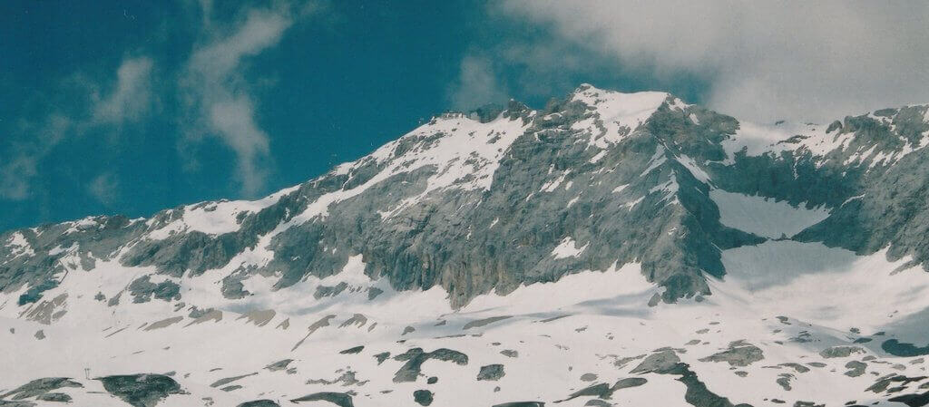
| Zugspitze, highest mountain in Germany.. |
Routes :
-
Reintal Valley Route - Start at the Olympic Ski Stadium. Follow track up to the Partnach Alm and on to the Reintal Valley. At the Angerhutte, climb steeply to the Knorrhutte where you spend the night. The following morning cross the Platt towards the Zugspitzbahn, turning north before you reach it. Climb the slope to the right of the concrete buildings, and keep a look out for the wire ropes to the right. Follow the klettersteig and way-markings to the summit platform.
-
Höllental Valley Route - Starting at Hammersbach, follow trail to the Höllentalanger Hut. Continue along valley to the start of the klettersteig, from were you'll need to put on your climbing harness and via ferrata kit. Cross the Höllentalferner (glacier) and climb steeply to the summit.
-
Neustädter Hut Route - This route ascends on the Austrian side of the mountain and begins from the Ehrwald - Zugspitzbahn cable car station. This route begins easily enough, following a path / ski run through the forested slopes, but a tricky klettersteig awaits. Overnighting at the
Neustädter Hut is recommended. This means a short first day, but leaves a full day to finish the ascent and follow another route down.
Getting there and away :
The nearest airport is Munich, however I took a cheap flight with Ryan Air to Frankfurt-Hann and hired a car from Hertz. The flight and drive took up a full day both ways. New flights are opening up all the time, so it is well worth have a hunt around.
The nearest train station is in Garmisch-Partenkirchen. To consult a rail timetable on-line, take a look at www.bahn.de.
Accommodation :
There is a wide range of accommodation available in and around Garmisch-Partenkirchen. The Garmisch-Partenkirchen Tourist Office can help you book valley accommodation in advance, and has plenty of information regarding local area, hiking, events, weather, etc. There are some great pictures here too.
There is a campsite on the B23 just west of the town, before you get to Grainau.
Once on the mountain, the network of huts run by the German Alpine Club (Deutscher Alpenverein, DAV for short) provides all the support for light weight hiking; snacks, hot meals, drinks, beds, sheets and blankets. A night's sleep in a hut is not cheap, so the discount given to members of UIAA affiliated clubs such as the BMC is appreciated.
Maps & Books :
| OpenStreetMaps. |
 Bayerisches Landesvermessungsamt produce an excellent 1:50,000 map, "Werdenfelser Land" showing both walking and klettersteig routes. Visit their website www.ldbv.bayern.de
There are 1:25,000 maps available from other publishers, but those I saw plot the contour lines at less regular intervals.
 Cicerone Press' "Klettersteig, Scrambles in the Northern Limestone Alps" by Paul Werner and translated by Deiter Pevsner, last published 1987, is the only English language guide to scrambling / klettersteig routes on the Zugspitze that I have found. It's available second hand online. ISBN 0902363468.
 In 2003 Rother published "Walks around the Zugspitze" by Dieter Siebert, and distributed by Cordee. ISBN 3763342427. As the name suggests, this is a walker's guide to the mountains. There are suggestions covering valley walks and some higher routes, including the decent from the Zugspitze. Take a look at their website at www.cordeee.co.uk..
Useful Links :
The German Tourist Board Website has useful fact about traveling to, accomodation, events, etc.
Zugspitze has has it's own website too.
You can read the latest UK government travel advise to Germany at www.gov.uk/foreign-travel-advice/germany.
For a weather forecast, check www.mountain-forecast.com.
