ESC -
Greece - Mytikas on Mount Olympus
, 2917m - Info | VR TourIntroduction :
First climbed in 1913 by Christos Kakalos, a native of the area, and the Swiss climbers Frederic Boissonas and Daniel Baud-Bovy, Mt. Olympus, abode of the ancient Greek gods, rises up straight from the Aegean Sea. Whilst the lower slopes are covered with a dense forest of cedar, holm oak, and arbutus, transitioning to oak, beach, and Balkan pine as the altitude rises, the mountain's seven summits are rocky and barren of water.
Routes :
There are a number of great routes to the roof of Greece. All are long and a minimum of two days is recommended. A high level of fitness is required, and a good head for heights as the final ascent to Mytikas requires an interesting scramble but no special tools unless attempted in winter. Here are the two main options...
Option 1: Litochoro via Refuge A
Distance: 18km
Ascent: 3420m
| Option 1: Litochoro via Refuge A. |
Those arriving at Prionia having hiked from Litochoro might wish to stop for a drink and a meal at the restaurant. But it is also a starting point for those who have driven this far. Continue on the E4 to Refuge A, perhaps staying here the night, before breaking through the tree line the following morning and first summiting peak of Skala (2866m). From Skala follow the ridge to Mytikas (2918m), and the highest of Mount Olympus' 55 summits.
Option 2: Gortsia via Refuge C or the S.E.O. Refuge
Distance: 14.5
Ascent: 2430
| Option 2: Gortsia via Refuge C or the S.E.O. Refuge. |
Having rested the night, you'll have two options. Those wishing to return the same way can borrow helmets from the S.E.O. Refuge and make a more direct climb to Mytikas via a col between it and its neighbour Stefani. This scramble is exposed but relatively easy, the danger coming from rock fall funnelled down the gulley up which one climbs.
Those wishing to see more of the mountain will contour beneath both Stefani and Mytikas then climb the 2866m Skala, from which an interesting ridge scramble is made to Mytikas.
Getting there and away :
The village of Litohoro is the mountain's eastern slope and most popular gateway and base camp for those wishing to make an ascent. It is 405 km by road from Athens and 90 km from Thessaloniki. The main rail line between these two cities passes nearby, Litohoro station being 9Km from the village itself. There are many buses daily too and from Katerini, Thessaloniki, and Athens. Thus the best option is to fly into Thessaloniki (SKG), take the shuttle bus on the 1X or 1N line through the city centre to the city bus / coach station. From the bus station take a coach direct to Litohoro, normally via Katerini.
Accommodation :
Within and around Litohoro there are plenty of hotels, hostels, and camping grounds. On the mountain there are number of huts, but unless you are making a prolonged stay, you're likely be staying at one of the following ...
Refuge A (aka Spilios Agapitos / Zolotas Refuge) is a stone building situated at 2060m on the E4 route that weaves it's way to the top of Mount Olympus. The refuge sleeps up to 110 visitors, and has cooking facilities that can serve guests in two large dining areas. All the necessary sanitary facilities are also provided in both of the refuges sleeping areas.
S.E.O. "Refuge Giosos Apostolidis" is the highest refuge at 2697m, located in a saddle below the “Profitis Ilias” peak. It can accommodate 80 people ,has a restaurant, toilets accessed from the outside, and runs from early June to October, with a winter refuge.
Refuge C "Christos Kakkalos" is located at 2648m, at the edge of the Muses Plateau. It can accommodate 23 people, a restaurant, and operates from early June to the end of October.
Maps and Books :
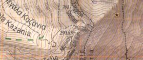
| OpenStreetMaps shows the ascent routes. |
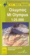
 Greek cartographers Anavasi have produced an excellent 1:25,000 hiking map "Mt Olympus", and printed it on a waterproof synthetic sheet. Trails, huts, and all the expected features are clearly marked, contours are at 20m intervals.
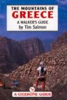 Cicerone Press published "The Mountains of Greece" by Tim Salmon. Whilst the guide covers the entire country, the section on Mt. Olympus is sufficient. Last published in 1993. ISBN 1-85284-108-7.
Useful Links :
www.www.visitgreece.gr is the official Greek tourist website.
The Olympus National Park - Management Agency. has great local information, hotels, restaurants, hiking etc.
You can read the latest UK government travel advise to Greece at www.gov.uk/foreign-travel-advice/greece.
For a weather forecast, check www.mountain-forecast.com.