ESC -
Denmark - Møllehøj / Baunehøj
, 171m - InfoIntroduction :
Ejer is the name of a nearby village, Baunehøj means beacon, as in a hill top bonfire for signalling.
Denmark’s official highpoint has had a varied history, some dispute its location even to this day. Here is a brief run down:
Prior to 1847 - People believed that Himmelbjerget ("Sky Mountain") was the highest point in Denmark, but it's only 147m.
1847 - Ejer Baunehøj was declared to be higher.
1874 - Ejer Baunehøj was measured to be 170.95m.
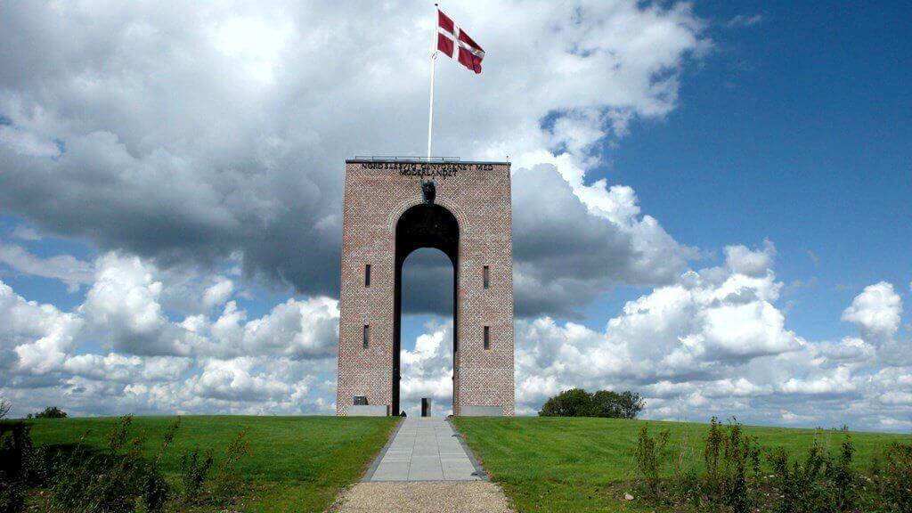
1924 - A thirteen metre tower was built at Ejer Baunehøj as a memorial of the reunion of the south of Jutland which was lost to Prussia in 1864, and reunited with Denmark after the First World War.
~1950 - Surveys suggest that a tree covered mound at Yding Skovhøj, 3km away is even higher.
1953 - The Danish Authorities decided that the extra height of Yding Skovhøj is artificial, the final few metres consisting of a bronze age burial mound. The crown was given back Ejer Baunehøj.
2002 - Both sites were re-surveyed, and both sites had sunk over the years, the new heights were recorded; Ejer Baunehøj 170.89 m, Yding Skovhøj 170.83 m
2005 - The 2002 survey had not settled the argument, so in Februray 2005 a expert panel made up of a made up of a geography professor, an archaeologist, and an office head at Denmark’s National Geographical Survey, set about to determine Denmarks high point. Remarkable a new high point was discovered in a farmers field 200 metres west of Ejer Baunehøj. The new highpoint is Møllehøj (Mill Top) at 170.86m. But that’s 3cm lower than Ejer Baunehøj I here you cry. But wait, Ejer Baunehøj was found to be 170.36 high. According to the international principle of Topographic Prominence, Møllehøj and Ejer Baunehøj are defined as one complete top.
When they came to re-survey Yding Skovhøj, they found a rise on it called Rodebuske to be 170.77m high.
Both Ejer Bavnehoj and Yding Skovhøj lie southwest of the town of Skanderborg amongst the hills and lakes of East Jutland, and can be visited in one trip. For further information click on www.ejer-baunehoj.dk. Both Møllehøj/Ejer Bavnehoj and Yding Skovhøj/Rodebuske are accessible by road.

|
| Tower on Ejer Baunehøj. |
Getting there and away :
The town of Skanderborg is the gateway to the hills and lakes of this area of Jutland.
Air - The nearest International Airport is Århus, but that at Esbjerg or Copenhagen would also be suitable depending on airfare and once internal transport costs are compared. Each Airport is served by the budget airlines.
Rail - The DSB (Danish State Railway) website has an English version on which your rail trip can be planned. Skanderborg is an approximately 20 mins ride from Århus, 2 hrs 20 mins from Esbjerg Airport, and 3 hrs 10 mins from Copenhagen Kastrup Airport.
Accommodation :
Camping - Visit www.visitskanderborg.dk for on line assistance in finding a campsite.
Hostels - There is a Youth Hostel in Skanderborg, visit www.danhostel.dk for further information.
Hotels - Visit www.visitskanderborg.dk for on line assistance in finding a hotel.
Maps & Books :
| OpenStreetMaps. |
Traditional walking maps for Denmark are hard to locate, Open Street Maps appears to be the best source of maping for the area.
Useful Links :
The Danish Tourist Board Website has useful fact about traveling to the Denmark.
You can read the latest UK government travel advise to Denmark at www.gov.uk/foreign-travel-advice/denmark.
For a weather forecast, check www.mountain-forecast.com.
