
ESC -
Cryprus - Mount Olmpus
, 1951m - Info | Trip ReportIntroduction :
Olympus, or Chionistra, (Greek: Όλυμπος or Χιονίστρα) is located in the Troodos Mountains of Cyprus. The very summit is out of bounds, being crowned by a British long range radar station. Whilst below there are ski resorts, Sun Valley and North Face, each with their own ski lifts. Both mean that access by car is very easy, but despite this lack of wilderness, an attractive hike to the summit can be acheived.
Routes:
 Southern Approach - Cold River Trail
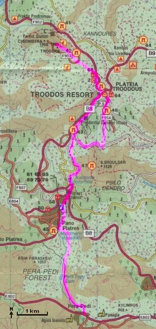
The best route I could put together began at Pera-Pedi, and follows the Kryos Potamos or Cold River for much of the way.
Approaching Pera-Pedi by road from the east, turn right up a narrow road into a hidden car park (the junction lies just before a bridge over the river is reached). Park here and follow the tarmac track northwards to the Pera-Pedi reservoir where the surface becomes one of broken stones. All this time the Kryos Potamos will have been flowing below you in the steep sided ravine to your left, often out of sight. Continue following the track northwards, remaining on the right hand side of the river until a junction, the left hand track is signposted to the Myllomaris water falls. Take this track which will loop around the hillside until reaching the falls. On the Hill side above, you will see the wooden panels fencing off a path. Take the trail (poorly marked and covered in parts by a land slide when I was there) up to meet the path protected by the fences. There are seats here where you rest and enjoy a the view. Continue on the path as it hugs the river bank, crossing to the western side only when the trail heads up to the town of Pano Platres. Walk on up through the town to the Denro Trout farm and the start of the Kalidonia nature trail. The nature trail crosses the river many times before finally arriving at it's northern terminus. Here there is room for car parking at the mouth of an unpaved forest trail. There are two options. Either head up on the snaking metalised road (parallel to the new road on the opposite side of a gully), or follow the forest track south east and then branching off on a overgrown path, northwards and steeply uphill to the summer houses. Either route will deliver you to Plateia Troodous. Close to the visitor centre, seek out the start of the Atalante nature trail and follow northwards as it contours the mountainside. The trail turns abruptly southwest at a dry river bed. Follow this river bed northwards, picking up a rarely used trail that, having crossed the Artemis trail, will bring you out on the summit road. Cross the road and follow the bulldozer trial to the summit station. You will not be able to enter the military compound, but circle it before descending the same way.
Getting there and away :
-
By Plane. There are regular sheduled and chartered flights to Pafos (PFO), and Larnica (LCA).
-
By Train. There are no rail service in Cyprus.
- By Road. The public can drive and park on the summit station access road, but this is not really within the spirit of the challenge. However your own car does give you the most freedom, allowing you to reach the mountain from which every resort you are staying. Since the south side is better service by trails, it is better to park at one of the towns and villages here. Two cars, or a taxi would allow you to make a south - north traverse on the central massive.
Maps & Books:
| OpenStreetMaps show the ascent route from Pera-Pedi. |
The Cypriot Tourist Organisation can provide a free map of the Troodos Mountains (see route above). This map has an unusually scale and should be used with caution as the position and existence of marked paths is not guaranteed. However, military and security concerns on the island mean that this is the only map currently available.
 Cicerone's "Walking in Cyprus", by Nike Werstroh and Jacint Mig, was published in 2017 covers 44 walking routes on Cyprus including trails in the Troodos.
ISBN 9781852848378
 Combined with the free tourist board map, an earlier edition of the
Rother's walking guide to Cyprus was my main source when planning my ascent. Since then a fourth edition was published in 2019.
Combined with the free tourist board map, an earlier edition of the
Rother's walking guide to Cyprus was my main source when planning my ascent. Since then a fourth edition was published in 2019.Written by Rolf Geotz and translated, it distributed in the UK by Cordee.
ISBN 978-3-7633-4814-5
Useful Links:
My Troodos offers information on the Troodos Mountains mytroodos.com.
You can read the latest UK government travel advise to Cyprus at www.gov.uk/foreign-travel-advice/cyprus.
For a weather forecast, check www.mountain-forecast.com.