It was on one such evening that I left my car in the National Trust car park below Mam Tor, lacing up boots whilst other walkers were removing theirs and preparing to return home. I followed the ridge of Rushup Edge to its summit, Lord's Seat, the site of an ancient cairn, a grass covered burial mound of some forgotten Bronze Age noble. The height of the sun suggested a few more hours of light as I then descended a rutted track westward to a junction with the Gospel Gate, the term "Gate", like in that in the Doctor's Gate which climbs from Glossop to the Snake Road, meaning a track or path. I followed the sandy cut of the Gospel Gate a short distance before branching off to the left, keeping a northward bearing toward Brown Knoll, whilst the Gate curved eastward and headed down towards Barber Booth. The path across the peaty moorland of Brown Knoll was eroded and boggy, in some places traitorously so. Yet it was peaceful, with not another sole in sight, the evening sun lighting up the white fluffy seed heads of cotton grass, the grouse called to each other, and a hare hid from sight upon my approach. Good news for those following in my footsteps, this path is paved now, but not then. It passes unnoticed over the 3,385m long Cowburn Tunnel that links Edale with Chapel-en-le-frith.
From the Ordnance Survey triangulation pillar on Brown Knoll's summit, I continued northwards, crossed drainage ditches and with a little relief joined a paved path that took me sure footed to join the
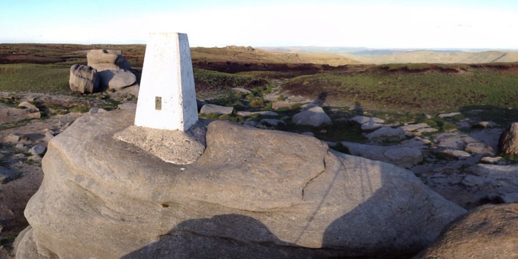
Pennine way. When it was opened in 1965, the 268 route was the first of Britain’s national trails. It begins at Edale in the valley below, ending 16 to 19 days later in Kirk Yetholm above the Cheviots. Following the way down into Edale was certainly an option that evening, but I wanted to strike the higher ground of the Kinder Plateau. This route also allowed me to follow the Pennine Way for a short distance, climbing pass the Swine's Back, Edale Rocks, and up to Kinder Lower, where the white painted triangulation pillar stands proudly cemented to a mighty gritstone lozenge. The temperature was dropping as the sun turned golden and neared the horizon, it was time to move on.

|
|
Kinder Low triangulation pillar standing proudly upon its mighty gritstone lozenge
|
A well-worn path not marked on the Ordnance Survey map took me to the southern edge of the plateau and the anvil like Noe Stool, and a little further on, Pym Chair. I had been using my phone to take panoramic pictures for these virtual tours and the inbuilt gps to record my track, but here the battery died. I continued on the Wool Pack, perhaps the most famous of Kinder's rock formations where the sunset's golden light upon the gritstone gave the shapes an almost magical air. I had pugged in an external battery pack to recharge my phone, but it was not yet ready. The view, the light upon the rocks was too good to miss. But it was cold, my fingers already turning white. I had an older camera that I could use for emergency, a Canon PowerShot SX200 with stitch assist. It would not give me the full 360 spherical image I was looking for from Microsoft's Photosynth app, but it would take a higher resolution photo. I chose my position balanced upon a gritstone bolder between two larger boulders, and began to take the series of images that I could later stitch into a 360 circle. Once round, twice round for a lower sweep, then a third rotation to gain some height to the picture. I was spending too much time in one place and was beginning to shiver. My phone had charged sufficiently, and I could use it again. So now I hurried on to Crowden Tower, and descended to Upper Booth by a path that crossed from one bank to the other of Crowden Brook. Nearing the bottom I passed unexpectedly through an enchanted wood, its floor covered with the most beautiful blue bells. It was almost dark now, and I cannot remember if it was this trip or another that I saw an owl for the first time in the wild, sitting atop a telephone pole. I stopped to watch it for a few minutes, hoping to retrieve the Canon PowerShot from my backpack before it flew away. Alas too late, and perhaps in the failing light, I would have been asking too much anyway. I followed the road by torch light back to my starting point.
The low resolution of many of these images is due to the use of Microsoft's Photosynth 360 photo app on my iPhone 4S. The maximum resolution a smart phone of this and many later generations can capture and process is 4096 x 2048 pixels. But the advantage of the app over a traditional point and shoot camera was the ability to capture full spherical images (if there is enough texture in the sky). The apps was discontinued in 2017.


